Helping Canadian customers find Jarritos nearby
A store locator has one job in the eyes of a customer: tell me where I can buy the product. The work behind that answer is less simple. Addresses change, retailers and restaurants need different treatment, national campaigns involve selected locations, and Canadian audiences expect the experience to work across languages.
Jarritos Canada needed control over both sides of the product. Customers needed a fast way to search, filter, and open directions. The Canadian brand team needed to maintain store data, import large updates, manage programme participation, and collect location photos without waiting for changes to the broader corporate website.
Priority Soft designed and built a standalone store locator with a mobile map and an administration portal. Customers get a short path to a store, while the Canadian team can keep the location data current.
A search flow that stays out of the way
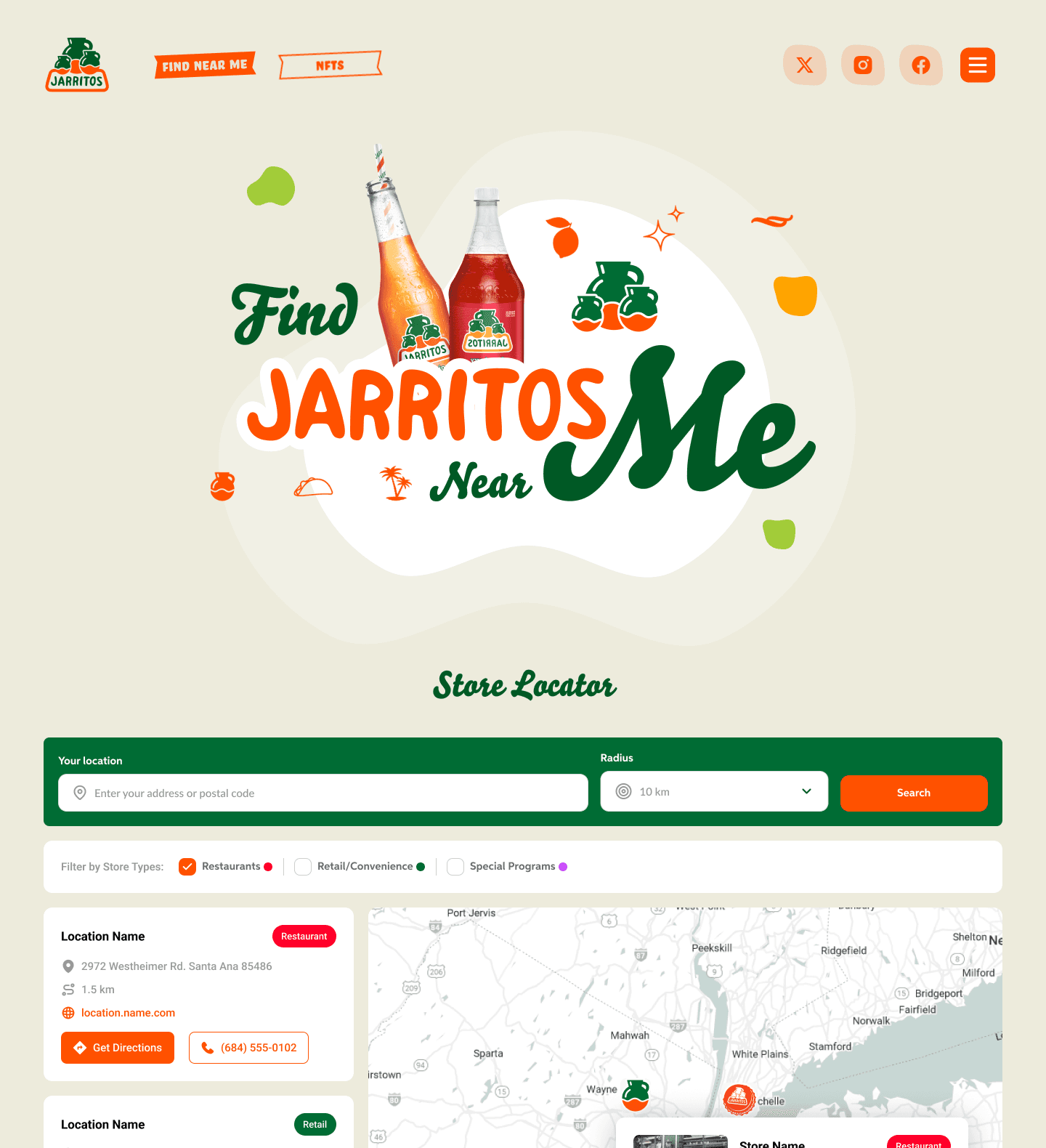
The public experience begins with a location. Visitors can share their current position or enter a Canadian city, postal code, or address. The locator finds nearby stores within the selected distance and shows the results on a map and in a readable list.
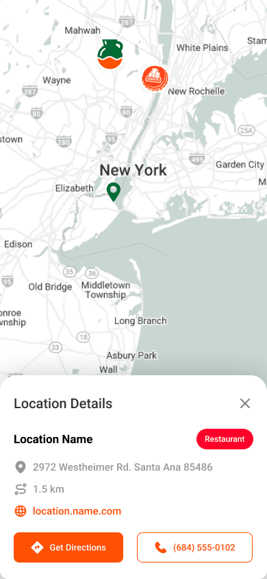
We kept the interaction short. A result card shows the store name, address, type, distance, and a directions button. Selecting a result focuses its marker and details on the same page.
The list and map work together. The map gives geographic context, while the list is easier to scan when several stores appear close to one another. On a phone, the layout gives both views enough room without forcing the user to pinch around a desktop map squeezed onto a smaller screen.
Search radius controls let customers adjust the results for a dense city or a remote area. The interface keeps their attention on the available stores.
Retailers, restaurants, and programme locations
Jarritos locations include restaurants, retailers, and stores that participate in a brand programme or campaign. Customers need to tell those options apart.
Visitors can filter results by store type and active programme. The first search shows all nearby options, and the filters let customers narrow the list afterward.
The Canadian team manages store types and programme participation on each location record. They can change either field without editing the website or keeping a second spreadsheet.
A campaign can feature participating stores or related content inside the same locator. Customers still use the same search to find Jarritos.
Designing for Canada's languages
Jarritos Canada serves customers in English and French, and the brand also speaks to a Spanish-speaking audience. We planned all three languages from the start.
English, French, and Spanish resources cover search, filters, store details, directions, empty states, errors, and administrative labels. Every language uses the same store dataset.
The structure keeps translations separate from application logic. The brand team can refine language without duplicating pages or maintaining three versions of the locator. New interface text has a clear place to be translated before it reaches customers.
Language also affects layout. Labels may be longer in one translation than another, especially on a mobile screen. We designed cards, controls, and navigation to accommodate that change without truncating the information people need.
Giving the Canadian team ownership of store data
A locator is only as good as its addresses. The polished map is the visible part, but stale or incomplete store data will undermine trust immediately.
Administrators can create or update one location directly. For larger updates, they can import a spreadsheet and process many records together.
The import records what the administrator submitted and whether each row succeeded. The team can fix a failed row without repeating the whole import. The same operation updates existing records and adds new stores.
A national list can establish or refresh the dataset. The portal also lets staff correct one phone number, change a store type, or deactivate a location later.
Turning addresses into reliable map results
Store data often arrives as human-readable addresses, but distance search needs coordinates. Formatting differences, missing postal codes, or an ambiguous street name can produce the wrong point if geocoding is treated as an unquestioned background step.
The Jarritos portal converts addresses into searchable map locations and gives administrators a chance to validate the result. Records can be corrected before they appear publicly, and inactive or incomplete locations stay out of customer search.
Store maintenance shows the address and mapped position as parts of the same record. The team can correct data before customers report a mistake.
The public search then works from approved coordinates. Results can be ordered by distance, placed accurately on the map, and handed to Google Maps for directions. The customer receives a direct answer built on data the Canadian team can inspect.
Collecting store photos without opening the admin portal
Store and field contacts may be the people best placed to provide an up-to-date location photo. Giving each contributor a full administrative account would create unnecessary access and training work.
A limited magic link gives the recipient access to one store image request without exposing other records or administration tools.
The access is narrow by design. The link is tied to the intended store and its use can be recorded. The contributor sees the upload task, while the brand team retains control over the wider location record and public presentation.
People outside the core team can submit one photo without receiving access to the full administration system.
Campaign and social content around the locator
The locator also supports campaign and social content. We place that material around the main search so customers can still find a store first.
Campaign sections sit around the locator. Programme filters connect campaigns to participating locations, while social content adds brand material after the core search.
The administration model keeps programme participation connected to store records. The public interface can therefore respond to a campaign without maintaining a separate list of locations behind the scenes.
Jarritos Canada can use the locator as a campaign page and keep it useful between promotions.
A full-stack product built for maintenance
The public locator and administration portal use Next.js, React, TypeScript, and Tailwind CSS. Google Maps and geocoding services provide search, distance, map display, and directions. A Django service layer with PostgreSQL manages stores, programmes, imports, limited-access uploads, and supporting content.
Managed object storage holds store media, while the translation system provides English, French, and Spanish interface resources. The public experience and internal portal share one data foundation but expose very different actions.
Imports, validation, programme management, and photo collection happen in controlled views away from the customer path. Public search receives approved active records through a lightweight interface.
That separation keeps the locator fast and easy to understand while giving the brand team the tools required to maintain it over time.
What Priority Soft brought to Jarritos Canada
Priority Soft saw the locator as a data product as much as a map. We designed the customer flow, but we also addressed how hundreds of locations enter the system, how a mistake is corrected, how programmes change, and how outside contacts contribute photos safely.
Search results come from records the Canadian team controls. Filters use the store types and programme memberships on those records. The interface supports three languages, and campaign content sits around the locator without blocking the search.
We then deployed the complete system and continued supporting data, language, and content updates. Jarritos Canada gained independence over a customer-facing tool without having to maintain a separate disconnected database behind it.
The outcome
Jarritos Canada now has a deployed store locator that answers the customer's question in a few steps. Visitors can search nearby, compare retailers and restaurants, filter relevant programmes, and open directions in English, French, or Spanish.
The brand team can import store lists, fix individual records, validate map positions, manage programme participation, and collect photos through limited links. Priority Soft delivered the public locator and the controls needed to maintain it after launch.